
Thank you for supporting this site ❤️
Make a donation
Make a donation
Lost Mountain topographic map
Click on the map to display elevation.
Thank you for supporting this site ❤️
Make a donation
Make a donation
About this map
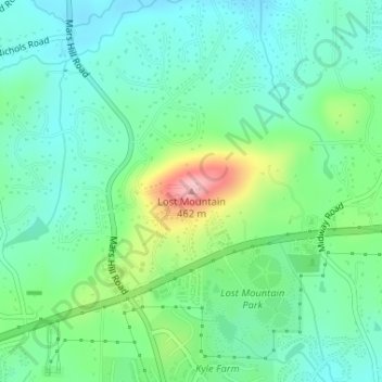
Name: Lost Mountain topographic map, elevation, terrain.
Location: Lost Mountain, Cobb County, Georgia, United States (33.94783 -84.69776 33.94793 -84.69766)
Average elevation: 340 m
Minimum elevation: 295 m
Maximum elevation: 459 m
Thank you for supporting this site ❤️
Make a donation
Make a donation
Other topographic maps
Click on a map to view its topography, its elevation and its terrain.