
Make a donation
Mestia topographic map
Click on the map to display elevation.
Make a donation
Mestia
Mestia (Georgian: მესტია IPA: [mɛstʼiɑ]) is a highland townlet (daba) in northwest Georgia, at an elevation of 1,500 metres (4,921 feet) in the Caucasus Mountains.
Make a donation
About this map
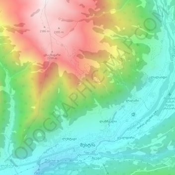
Name: Mestia topographic map, elevation, terrain.
Location: Mestia, Mestia Municipality, Samegrelo-Upper Svaneti, Georgia (43.03879 42.70968 43.07569 42.75821)
Average elevation: 1,770 m
Minimum elevation: 1,345 m
Maximum elevation: 2,445 m
Make a donation
Other topographic maps
Click on a map to view its topography, its elevation and its terrain.
Chazhashi
Georgia > Samegrelo-Upper Svaneti > Mestia Municipality > Ushguli
Chazhashi (Georgian: ჩაჟაში) is a village in the Mestia Municipality, Samegrelo-Zemo Svaneti, Georgia. It is located in the southern foothills of the Greater Caucasus mountains, in the upper Enguri River valley, at the elevation of 2,160 m above sea level. The village is part of the historical…
Average elevation: 2,405 m