
Make a donation
Delmar topographic map
Click on the map to display elevation.
Make a donation
About this map
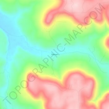
Name: Delmar topographic map, elevation, terrain.
Location: Delmar, Carroll County, Arkansas, United States (36.14063 -93.36102 36.18063 -93.32102)
Average elevation: 535 m
Minimum elevation: 416 m
Maximum elevation: 675 m
Make a donation
Other topographic maps
Click on a map to view its topography, its elevation and its terrain.
Eureka Springs
United States > Arkansas > Carroll County
It is a tourist destination for its unique character as a Victorian resort, which first attracted visitors to use its then believed healing springs. The city has steep winding streets filled with Victorian-style cottages and manors. The historic commercial downtown of the city has an extensive streetscape of…
Average elevation: 411 m
Eureka Springs
United States > Arkansas > Carroll County
It is a tourist destination for its unique character as a Victorian resort, which first attracted visitors to use its then-believed healing springs. The city has steep, winding streets filled with Victorian-style cottages and manors. The historic commercial downtown of the city has an extensive streetscape of…
Average elevation: 411 m
Eureka Springs
United States > Arkansas > Carroll County
It is a tourist destination for its unique character as a Victorian resort, which first attracted visitors to use its then believed healing springs. The city has steep winding streets filled with Victorian-style cottages and manors. The historic commercial downtown of the city has an extensive streetscape of…
Average elevation: 411 m
Eureka Springs
United States > Arkansas > Carroll County
It is a tourist destination for its unique character as a Victorian resort, which first attracted visitors to use its then believed healing springs. The city has steep winding streets filled with Victorian-style cottages and manors. The historic commercial downtown of the city has an extensive streetscape of…
Average elevation: 411 m
Make a donation
Make a donation