
Thank you for supporting this site ❤️
Make a donation
Make a donation
Berryville topographic map
Click on the map to display elevation.
Thank you for supporting this site ❤️
Make a donation
Make a donation
About this map
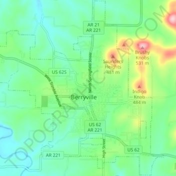
Name: Berryville topographic map, elevation, terrain.
Location: Berryville, Carroll County, Arkansas, 72616, United States (36.34665 -93.60588 36.39976 -93.53482)
Average elevation: 376 m
Minimum elevation: 320 m
Maximum elevation: 530 m
Thank you for supporting this site ❤️
Make a donation
Make a donation
Other topographic maps
Click on a map to view its topography, its elevation and its terrain.
Thank you for supporting this site ❤️
Make a donation
Make a donation
Eureka Springs
United States > Arkansas > Carroll County > Eureka Springs
It is a tourist destination for its unique character as a Victorian resort village. The city has steep winding streets filled with Victorian-style cottages and manors. The historic commercial downtown of the city has an extensive streetscape of well-preserved Victorian buildings. The buildings are primarily…
Average elevation: 417 m