
Make a donation
Quiogue topographic map
Click on the map to display elevation.
Make a donation
Quiogue
Quiogue is located at 40°49′11″N 072°37′44″W / 40.81972°N 72.62889°W / 40.81972; -72.62889 (40.8198217, -72.6289837) and its elevation is 23 feet (7 m).
Make a donation
About this map
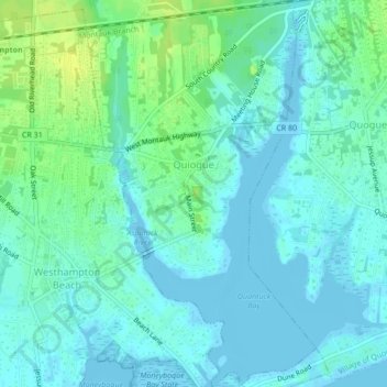
Name: Quiogue topographic map, elevation, terrain.
Average elevation: 5 m
Minimum elevation: -4 m
Maximum elevation: 16 m
Make a donation
Other topographic maps
Click on a map to view its topography, its elevation and its terrain.
Sag Harbor
United States > New York > Suffolk County > Sag Harbor > Sag Harbor
Average elevation: 13 m
Make a donation
Stony Brook University
United States > New York > Suffolk County > Town of Brookhaven
Average elevation: 46 m
Port Jefferson Harbor
United States > New York > Suffolk County > Town of Brookhaven
Average elevation: 10 m
East Hampton
United States > New York > Suffolk County > East Hampton > Village of East Hampton
Average elevation: 12 m
Make a donation
South Jamesport
United States > New York > Suffolk County > Town of Riverhead > Jamesport
Average elevation: 2 m
West Tiana
United States > New York > Suffolk County > Hampton Bays > Town of Southampton
Average elevation: 8 m
West Point
United States > New York > Suffolk County > Hampton Bays > Town of Southampton > Rampasture
Average elevation: 3 m
Make a donation
Port Jefferson
United States > New York > Suffolk County > Port Jefferson > Port Jefferson
It wasn't until 1836 that the local leadership truly initiated the community's transition from a swampish hamlet to a bustling port town. Twenty-two acres of the harborfront, which flooded with the tides, were brought to a stable elevation with the construction of a causeway. Concurrently, the village was…
Average elevation: 26 m
Ditch Plains
United States > New York > Suffolk County > Town of East Hampton > Montauk
Average elevation: 5 m
Make a donation
Wildwood State Park
United States > New York > Suffolk County > Wading River > Wildwood
Average elevation: 28 m
Westmoreland
United States > New York > Suffolk County > Shelter Island Heights
Average elevation: 4 m
Rampasture
United States > New York > Suffolk County > Hampton Bays > Town of Southampton
Average elevation: 4 m
Make a donation
Make a donation
Lonelyville
United States > New York > Suffolk County > Town of Islip > Fair Harbor
Average elevation: 0 m
Make a donation
Montauk Station
United States > New York > Suffolk County > Town of East Hampton > Montauk
Average elevation: 11 m
Springville
United States > New York > Suffolk County > Hampton Bays > Town of Southampton
Average elevation: 10 m
Make a donation
Make a donation
Southampton
United States > New York > Suffolk County > Southampton > Southampton
Average elevation: 6 m
Make a donation
East Hauppauge
United States > New York > Suffolk County > Town of Smithtown > Nesconset > East Hauppauge
Average elevation: 28 m
Rose Grove
United States > New York > Suffolk County > North Sea > Town of Southampton
Average elevation: 15 m
Old Mastic
United States > New York > Suffolk County > Mastic Beach > Town of Brookhaven
Average elevation: 4 m
Make a donation