
Make a donation
Pari Maatri Taal topographic map
Click on the map to display elevation.
Make a donation
About this map
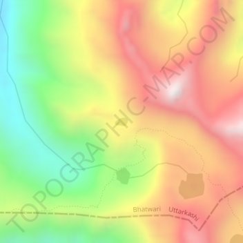
Name: Pari Maatri Taal topographic map, elevation, terrain.
Location: Pari Maatri Taal, Bhatwari, Uttarkashi, Uttarakhand, India (30.73243 78.79767 30.73333 78.79930)
Average elevation: 4,443 m
Minimum elevation: 3,934 m
Maximum elevation: 4,917 m
Make a donation
Other topographic maps
Click on a map to view its topography, its elevation and its terrain.
Uttarkashi
India > Uttarakhand > Bhatwari
It is the district headquarters of Uttarkashi district. Uttarkashi is situated on the banks of river Bhagirathi at an altitude of 1158 m above sea level. Uttarkashi is generally known as a holy town close to Rishikesh. It is located in the state of Uttarakhand in India. Uttarkashi is home to a number of…
Average elevation: 1,619 m
Make a donation
Make a donation
Gomukh, Ice Cave
India > Uttarakhand > Bhatwari
Around the snout, nature presents a wild topography. There are boulders scattered here and there with some pieces of broken snow, along with the hard clayey snow of the glacier.
Average elevation: 4,286 m
Make a donation
Make a donation