
Make a donation
Ushers Road State Forest topographic map
Click on the map to display elevation.
Make a donation
About this map
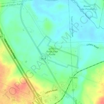
Name: Ushers Road State Forest topographic map, elevation, terrain.
Average elevation: 63 m
Minimum elevation: 43 m
Maximum elevation: 105 m
Make a donation
Other topographic maps
Click on a map to view its topography, its elevation and its terrain.
Saratoga Springs
United States > New York > Saratoga County > Saratoga Springs
Average elevation: 161 m
Make a donation
Make a donation
Vischer Ferry
United States > New York > Saratoga County > Town of Clifton Park
Average elevation: 74 m
Make a donation
Halfmoon
United States > New York > Saratoga County > Halfmoon
Halfmoon is a town in Saratoga County, New York, United States. The population was 21,535 at the 2010 census. The town is apparently named for the shape of the lower elevation land north of the junction of the Hudson and Mohawk Rivers. It is also said to be named for Henry Hudson's ship.
Average elevation: 84 m
Elnora
United States > New York > Saratoga County > Town of Clifton Park > Elnora
Average elevation: 98 m
Make a donation