
Thank you for supporting this site ❤️
Make a donation
Make a donation
Hagedorns Mills topographic map
Click on the map to display elevation.
Thank you for supporting this site ❤️
Make a donation
Make a donation
About this map
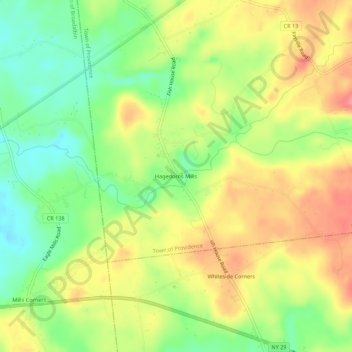
Name: Hagedorns Mills topographic map, elevation, terrain.
Average elevation: 314 m
Minimum elevation: 274 m
Maximum elevation: 354 m
Thank you for supporting this site ❤️
Make a donation
Make a donation
Other topographic maps
Click on a map to view its topography, its elevation and its terrain.
Saratoga Spa State Park
United States > New York > Saratoga County > City of Saratoga Springs
Average elevation: 91 m
Country Knolls
United States > New York > Saratoga County > Town of Clifton Park
Average elevation: 86 m
Thank you for supporting this site ❤️
Make a donation
Make a donation
North Ballston Spa
United States > New York > Saratoga County > Town of Milton
Average elevation: 106 m
Thank you for supporting this site ❤️
Make a donation
Make a donation
Village of Round Lake
United States > New York > Saratoga County > Town of Malta
Average elevation: 62 m