
Thank you for supporting this site ❤️
Make a donation
Make a donation
Robe topographic map
Click on the map to display elevation.
Thank you for supporting this site ❤️
Make a donation
Make a donation
About this map
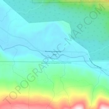
Name: Robe topographic map, elevation, terrain.
Location: Robe, Snohomish County, Washington, United States (48.07625 -121.82632 48.11625 -121.78632)
Average elevation: 407 m
Minimum elevation: 265 m
Maximum elevation: 878 m
Thank you for supporting this site ❤️
Make a donation
Make a donation
Other topographic maps
Click on a map to view its topography, its elevation and its terrain.
Thank you for supporting this site ❤️
Make a donation
Make a donation
Thank you for supporting this site ❤️
Make a donation
Make a donation
Seattle Hill-Silver Firs
United States > Washington > Snohomish County > Seattle Hill-Silver Firs
Average elevation: 93 m
Thank you for supporting this site ❤️
Make a donation
Make a donation