
Make a donation
Bowser Lake topographic map
Click on the map to display elevation.
Make a donation
About this map
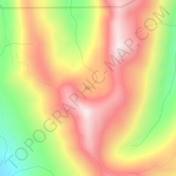
Name: Bowser Lake topographic map, elevation, terrain.
Location: Bowser Lake, Snohomish County, Washington, United States (47.97234 -121.26045 47.97303 -121.25869)
Average elevation: 1,393 m
Minimum elevation: 976 m
Maximum elevation: 1,713 m
Make a donation
Other topographic maps
Click on a map to view its topography, its elevation and its terrain.
Make a donation
Make a donation
Make a donation
Make a donation
Make a donation
Granite Falls
United States > Washington > Snohomish County > Granite Falls > Granite Falls
Average elevation: 143 m
Totem Park
United States > Washington > Snohomish County > Arlington > Totem Park
Average elevation: 34 m
Make a donation
Mill Creek
United States > Washington > Snohomish County > Mill Creek > Mill Creek
Average elevation: 129 m
Snohomish
United States > Washington > Snohomish County > Snohomish > Snohomish
Average elevation: 36 m
Seattle Hill-Silver Firs
United States > Washington > Snohomish County > Seattle Hill-Silver Firs
Average elevation: 93 m
Make a donation