
Thank you for supporting this site ❤️
Make a donation
Make a donation
Bryant topographic map
Click on the map to display elevation.
Thank you for supporting this site ❤️
Make a donation
Make a donation
About this map
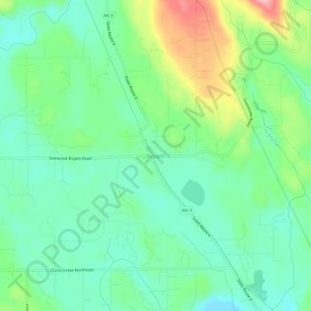
Name: Bryant topographic map, elevation, terrain.
Location: Bryant, Snohomish County, Washington, United States (48.21899 -122.17792 48.25899 -122.13792)
Average elevation: 63 m
Minimum elevation: 15 m
Maximum elevation: 171 m
Thank you for supporting this site ❤️
Make a donation
Make a donation
Other topographic maps
Click on a map to view its topography, its elevation and its terrain.
Thank you for supporting this site ❤️
Make a donation
Make a donation
Thank you for supporting this site ❤️
Make a donation
Make a donation
Seattle Hill-Silver Firs
United States > Washington > Snohomish County > Seattle Hill-Silver Firs
Average elevation: 93 m
Thank you for supporting this site ❤️
Make a donation
Make a donation