
Thank you for supporting this site ❤️
Make a donation
Make a donation
Monte Cristo topographic map
Click on the map to display elevation.
Thank you for supporting this site ❤️
Make a donation
Make a donation
About this map
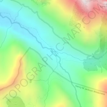
Name: Monte Cristo topographic map, elevation, terrain.
Location: Monte Cristo, Snohomish County, Washington, United States (47.97573 -121.40359 47.99573 -121.38359)
Average elevation: 1,179 m
Minimum elevation: 766 m
Maximum elevation: 1,972 m
Thank you for supporting this site ❤️
Make a donation
Make a donation
Other topographic maps
Click on a map to view its topography, its elevation and its terrain.
Thank you for supporting this site ❤️
Make a donation
Make a donation
Thank you for supporting this site ❤️
Make a donation
Make a donation
Seattle Hill-Silver Firs
United States > Washington > Snohomish County > Seattle Hill-Silver Firs
Average elevation: 93 m
Thank you for supporting this site ❤️
Make a donation
Make a donation