
Thank you for supporting this site ❤️
Make a donation
Make a donation
Pine Center topographic map
Click on the map to display elevation.
Thank you for supporting this site ❤️
Make a donation
Make a donation
About this map
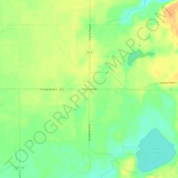
Name: Pine Center topographic map, elevation, terrain.
Location: Pine Center, Crow Wing County, Minnesota, United States (46.19441 -93.93443 46.23441 -93.89443)
Average elevation: 397 m
Minimum elevation: 379 m
Maximum elevation: 413 m
Thank you for supporting this site ❤️
Make a donation
Make a donation
Other topographic maps
Click on a map to view its topography, its elevation and its terrain.
Thank you for supporting this site ❤️
Make a donation
Make a donation
Ossawinnamakee Lake
United States > Minnesota > Crow Wing County > Breezy Point
Average elevation: 380 m