
Thank you for supporting this site ❤️
Make a donation
Make a donation
Bird Island topographic map
Click on the map to display elevation.
Thank you for supporting this site ❤️
Make a donation
Make a donation
About this map
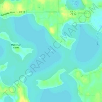
Name: Bird Island topographic map, elevation, terrain.
Location: Bird Island, Crow Wing County, Minnesota, United States (46.39968 -93.84984 46.40026 -93.84885)
Average elevation: 386 m
Minimum elevation: 380 m
Maximum elevation: 401 m
Thank you for supporting this site ❤️
Make a donation
Make a donation
Other topographic maps
Click on a map to view its topography, its elevation and its terrain.
Thank you for supporting this site ❤️
Make a donation
Make a donation
Thank you for supporting this site ❤️
Make a donation
Make a donation
Ossawinnamakee Lake
United States > Minnesota > Crow Wing County > Breezy Point
Average elevation: 380 m