
Thank you for supporting this site ❤️
Make a donation
Make a donation
Ismailia Governorate topographic map
Click on the map to display elevation.
Thank you for supporting this site ❤️
Make a donation
Make a donation
About this map
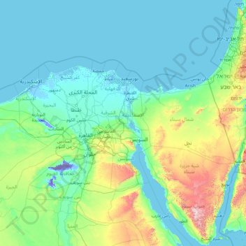
Name: Ismailia Governorate topographic map, elevation, terrain.
Location: Ismailia Governorate, Egypt (27.76720 29.55655 32.96720 34.75655)
Average elevation: 188 m
Minimum elevation: -47 m
Maximum elevation: 2,424 m
Thank you for supporting this site ❤️
Make a donation
Make a donation
Other topographic maps
Click on a map to view its topography, its elevation and its terrain.
Sinai Peninsula
Sinai is one of the coldest provinces in Egypt because of its high altitudes and mountainous topographies. Winter temperatures in some of Sinai's cities and towns reach −16 °C (3 °F).
Average elevation: 457 m