
Thank you for supporting this site ❤️
Make a donation
Make a donation
Bill Lake topographic map
Click on the map to display elevation.
Thank you for supporting this site ❤️
Make a donation
Make a donation
About this map
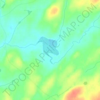
Name: Bill Lake topographic map, elevation, terrain.
Location: Bill Lake, Lake County, Minnesota, United States (47.80728 -91.07127 47.81450 -91.06254)
Average elevation: 510 m
Minimum elevation: 493 m
Maximum elevation: 538 m
Thank you for supporting this site ❤️
Make a donation
Make a donation
Other topographic maps
Click on a map to view its topography, its elevation and its terrain.
Boundary Waters Canoe Area Wilderness
United States > Minnesota > Lake County
Average elevation: 423 m
Thank you for supporting this site ❤️
Make a donation
Make a donation