
Thank you for supporting this site ❤️
Make a donation
Make a donation
Mud Lake topographic map
Click on the map to display elevation.
Thank you for supporting this site ❤️
Make a donation
Make a donation
About this map
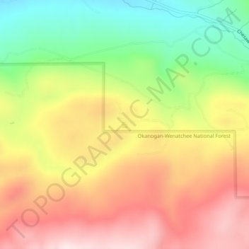
Name: Mud Lake topographic map, elevation, terrain.
Location: Mud Lake, Okanogan County, Washington, United States (48.93093 -119.33932 48.93172 -119.33836)
Average elevation: 813 m
Minimum elevation: 563 m
Maximum elevation: 1,046 m
Thank you for supporting this site ❤️
Make a donation
Make a donation
Other topographic maps
Click on a map to view its topography, its elevation and its terrain.
Thank you for supporting this site ❤️
Make a donation
Make a donation
Thank you for supporting this site ❤️
Make a donation
Make a donation