
Make a donation
Wauconda topographic map
Click on the map to display elevation.
Make a donation
About this map
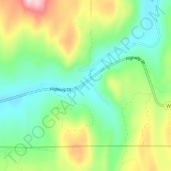
Name: Wauconda topographic map, elevation, terrain.
Location: Wauconda, Okanogan County, Washington, United States (48.70572 -119.03365 48.74572 -118.99365)
Average elevation: 1,183 m
Minimum elevation: 1,074 m
Maximum elevation: 1,399 m
Make a donation
Other topographic maps
Click on a map to view its topography, its elevation and its terrain.
Make a donation
Chopaka Lake
United States > Washington > Okanogan County
Chopaka Lake is a lake in Okanogan County, Washington. It covers an area of approximately 150 acres (0.6 km2), is over 70 ft (21 m) deep at its deepest point, and is 2,910 ft (886 m) in elevation. The lake's name is that of a legendary Okanogan hunter who was transformed to stone by Coyote. It serves as an…
Average elevation: 1,032 m
Grand Coulee Dam
United States > Washington > Okanogan County
After power shortages in the Northwest during the 1960s, it was determined the six remaining planned pumps be pump-generators. When energy demand is high, the pump-generators can generate electricity with water from the Banks Lake feeder canal adjacent to the dam at a higher elevation. By 1973, the…
Average elevation: 423 m
Make a donation