
Thank you for supporting this site ❤️
Make a donation
Make a donation
Alcubierre topographic map
Click on the map to display elevation.
Thank you for supporting this site ❤️
Make a donation
Make a donation
About this map
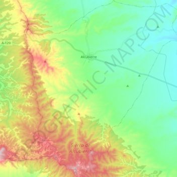
Name: Alcubierre topographic map, elevation, terrain.
Location: Alcubierre, Los Monegros, Huesca, Aragón, España (41.71515 -0.51962 41.85070 -0.36003)
Average elevation: 518 m
Minimum elevation: 360 m
Maximum elevation: 825 m
Thank you for supporting this site ❤️
Make a donation
Make a donation
Other topographic maps
Click on a map to view its topography, its elevation and its terrain.
Thank you for supporting this site ❤️
Make a donation
Make a donation
Thank you for supporting this site ❤️
Make a donation
Make a donation