
Thank you for supporting this site ❤️
Make a donation
Make a donation
Leonta topographic map
Click on the map to display elevation.
Thank you for supporting this site ❤️
Make a donation
Make a donation
About this map
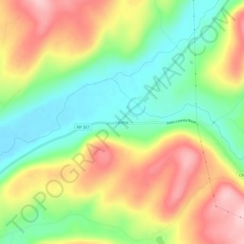
Name: Leonta topographic map, elevation, terrain.
Average elevation: 460 m
Minimum elevation: 362 m
Maximum elevation: 580 m
Thank you for supporting this site ❤️
Make a donation
Make a donation
Other topographic maps
Click on a map to view its topography, its elevation and its terrain.
Village of Hancock
United States > New York > Delaware County > Town of Hancock > Village of Hancock
Average elevation: 336 m
Thank you for supporting this site ❤️
Make a donation
Make a donation
Village of Franklin
United States > New York > Delaware County > Town of Franklin
Average elevation: 419 m
Chipmunk Hollow Unit
United States > New York > Delaware County > Town of Walton
Average elevation: 575 m
Thank you for supporting this site ❤️
Make a donation
Make a donation