
Make a donation
Sprague Road Unit topographic map
Click on the map to display elevation.
Make a donation
About this map
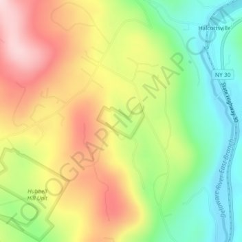
Name: Sprague Road Unit topographic map, elevation, terrain.
Average elevation: 551 m
Minimum elevation: 414 m
Maximum elevation: 708 m
Make a donation
Other topographic maps
Click on a map to view its topography, its elevation and its terrain.
Make a donation
Make a donation
Make a donation
South Kortright
United States > New York > Delaware County > Town of Stamford
Average elevation: 528 m
Make a donation
Village of Hancock
United States > New York > Delaware County > Town of Hancock > Village of Hancock
Average elevation: 336 m
Village of Franklin
United States > New York > Delaware County > Town of Franklin
Average elevation: 419 m
Make a donation
Harpersfield
United States > New York > Delaware County > Town of Harpersfield > Harpersfield
Average elevation: 594 m
East Masonville
United States > New York > Delaware County > Town of Masonville
Average elevation: 551 m
Make a donation
Chipmunk Hollow Unit
United States > New York > Delaware County > Town of Walton
Average elevation: 575 m
West Davenport
United States > New York > Delaware County > Town of Davenport
Average elevation: 453 m
Make a donation