
Thank you for supporting this site ❤️
Make a donation
Make a donation
Howard topographic map
Click on the map to display elevation.
Thank you for supporting this site ❤️
Make a donation
Make a donation
About this map
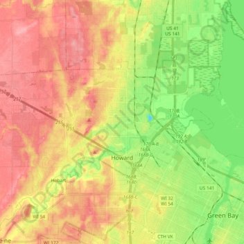
Name: Howard topographic map, elevation, terrain.
Location: Howard, Brown County, Wisconsin, 54313, United States (44.53013 -88.19536 44.59464 -88.01298)
Average elevation: 199 m
Minimum elevation: 150 m
Maximum elevation: 241 m
Thank you for supporting this site ❤️
Make a donation
Make a donation
Other topographic maps
Click on a map to view its topography, its elevation and its terrain.
Depere Lock and Dam
United States > Wisconsin > Brown County > De Pere > West De Pere
Average elevation: 186 m
Thank you for supporting this site ❤️
Make a donation
Make a donation
Thank you for supporting this site ❤️
Make a donation
Make a donation