
Thank you for supporting this site ❤️
Make a donation
Make a donation
Shady Acres topographic map
Click on the map to display elevation.
Thank you for supporting this site ❤️
Make a donation
Make a donation
About this map
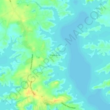
Name: Shady Acres topographic map, elevation, terrain.
Average elevation: 115 m
Minimum elevation: 108 m
Maximum elevation: 134 m
Thank you for supporting this site ❤️
Make a donation
Make a donation
Other topographic maps
Click on a map to view its topography, its elevation and its terrain.
Oak Grove
United States > South Carolina > Lexington County > Lakeview Terrace
Average elevation: 97 m
Peachtree Rock Heritage Preserve
United States > South Carolina > Lexington County
Average elevation: 148 m
Thank you for supporting this site ❤️
Make a donation
Make a donation