
Thank you for supporting this site ❤️
Make a donation
Make a donation
Lake Murray topographic map
Click on the map to display elevation.
Thank you for supporting this site ❤️
Make a donation
Make a donation
About this map
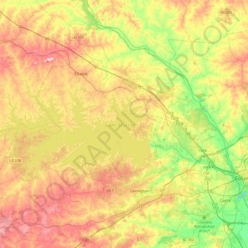
Name: Lake Murray topographic map, elevation, terrain.
Location: Lake Murray, Lexington County, South Carolina, United States (33.99849 -81.69007 34.17160 -81.21652)
Average elevation: 113 m
Minimum elevation: 33 m
Maximum elevation: 240 m
Thank you for supporting this site ❤️
Make a donation
Make a donation
Other topographic maps
Click on a map to view its topography, its elevation and its terrain.
Peachtree Rock Heritage Preserve
United States > South Carolina > Lexington County
Average elevation: 148 m
Batesburg
United States > South Carolina > Lexington County > Batesburg-Leesville
Average elevation: 186 m
Thank you for supporting this site ❤️
Make a donation
Make a donation
Thank you for supporting this site ❤️
Make a donation
Make a donation
Thank you for supporting this site ❤️
Make a donation
Make a donation