
Make a donation
Glen Etive topographic map
Click on the map to display elevation.
Make a donation
About this map
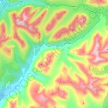
Name: Glen Etive topographic map, elevation, terrain.
Location: Glen Etive, Highland, Scotland, United Kingdom (56.56203 -5.07043 56.65180 -4.84400)
Average elevation: 477 m
Minimum elevation: 0 m
Maximum elevation: 1,137 m
Make a donation
Other topographic maps
Click on a map to view its topography, its elevation and its terrain.
Ben Nevis
United Kingdom > Scotland > Highland
Ben Nevis has a highland (alpine) maritime (oceanic) polar climate (ET climate in the Köppen classification). Ben Nevis's elevation, maritime location and topography frequently lead to cool and cloudy weather conditions, which can pose a danger to ill-equipped walkers. According to the observations carried…
Average elevation: 912 m
Fort William
United Kingdom > Scotland > Highland
Fort William has an oceanic climate (Cfb) with moderate, but generally cool, temperatures and abundant precipitation. In the towns immediate vicinity, there are significant variations in elevation, which leads to some uninhabited areas near the town having a subpolar oceanic climate (Cfc), or, at the absolute…
Average elevation: 122 m
Make a donation
Make a donation
Skye
United Kingdom > Scotland > Highland
Beyond Loch Snizort to the west of Trotternish is the Waternish peninsula, which ends in Ardmore Point's double rock arch. Duirinish peninsula is separated from Waternish by Loch Dunvegan, which contains the island of Isay. It is ringed by sea cliffs that reach 296 metres (971 feet) on the west at Waterstein…
Average elevation: 63 m
Make a donation
Aonach Beag
United Kingdom > Scotland > Highland
Aonach Beag is linked to its close neighbour to the north, Aonach Mòr, by a high saddle or bealach. The name Aonach Beag (small ridge) might imply that this mountain is smaller than Aonach Mòr (big ridge). However, Aonach Beag is higher; the names refer to the relative bulk of the two mountains rather than…
Average elevation: 873 m
Càrn Eige
United Kingdom > Scotland > Highland
Carn Eighe (Scottish Gaelic: Càrn Èite) is a mountain in the Northwest Highlands of Scotland. Rising to 1,183 metres (3,881 ft) above sea level, it is the highest mountain in Scotland north of the Great Glen, the twelfth-highest in the British Isles, and, in terms of relative height (topographic prominence),…
Average elevation: 867 m
Make a donation
Make a donation
Ben Klibreck
United Kingdom > Scotland > Highland
Ben Klibreck (Scottish Gaelic: Beinn Chlìbric) is a Scottish mountain located in central Sutherland. It is an isolated mountain, rising above a large area of moorland. The highest point, Meall nan Con (the mound of the dogs), rises to 962 metres (3,156 ft) elevation and is therefore the second most northerly…
Average elevation: 551 m
Canisp
United Kingdom > Scotland > Highland
Canisp is an isolated mountain that stands in the Glencanisp Forest, a large rock and water wilderness. It has a topographic prominence of 691 metres (2,267 ft). Canisp has little vegetation, even on its lower slopes large areas of Gneiss (one of the oldest rocks in the world) are visible on the surface.
Average elevation: 467 m
Make a donation
Make a donation
Sgùrr na Lapaich
United Kingdom > Scotland > Highland
With a topographic prominence of 839 metres, Sgurr na Lapaich is the highest point for some considerable distance and is a fine viewpoint. The mountain is particularly well seen from the east; it is a prominent landmark as far away as the Moray Firth, some thirty miles away, from where locals use it as a guide…
Average elevation: 796 m
Make a donation
Sgùrr Fhuaran
United Kingdom > Scotland > Highland
The mountain reaches a height of 1,067 metres (3,501 ft) and qualifies as a Munro and a Marilyn; it is the highest point for a significant distance, having a sizeable topographic prominence of 663 metres (2,175 ft) and giving extensive views from its summit.
Average elevation: 604 m
Sgùrr na Càrnach
United Kingdom > Scotland > Highland
From 1891 to 1997 Sgùrr na Càrnach was ranked as just a "Top" of the nearby Munro of Sgùrr Fhuraran and was not given separate Munro status, however in the 1997 revision of the tables by the Scottish Mountaineering Club, the mountain was elevated to the Munro category as it was decided that with 134 metres…
Average elevation: 589 m
Make a donation
Make a donation
Make a donation
Make a donation
Sgúrr nan Eugallt
United Kingdom > Scotland > Highland
An old stalkers' path from the ruined cottage should guide the climber to a point just below a ridge at about 650 metres. The path was well built in its time but some sections have become wet and slippery. On gaining the ridge, turn left and follow the ridge to the 894 m triangulation point. The ridge becomes…
Average elevation: 539 m
Make a donation
Make a donation
Make a donation
Make a donation
Make a donation
Make a donation
Make a donation
Make a donation
Make a donation
Make a donation
Make a donation
Make a donation
Make a donation