
沈阳市 topographic map
Interactive map
Click on the map to display elevation.
About this map
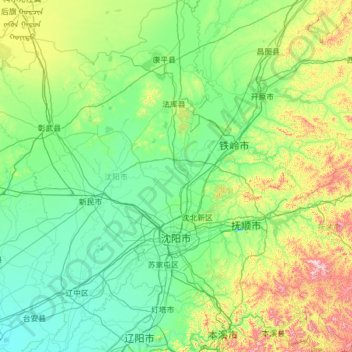
Name: 沈阳市 topographic map, elevation, terrain.
Location: 沈阳市, 辽宁省, 中国 (41.19769 122.41674 43.04030 123.80854)
Average elevation: 155 m
Minimum elevation: 3 m
Maximum elevation: 1,101 m
沈阳地处辽河、浑河冲积平原,地势平坦,以平原为主,平均海拔约为50米。沈阳的地貌骨架基本上形成于两亿年前的中生代燕山构造期,地势由东北向西南缓缓倾斜。东部因与靖宇台拱的凡河凹陷相邻,故为低山地貌,西部属平原与燕山台褶带接壤。沈阳全市境内最高点为法库县庙台山,海拔447.2米。沈阳最低点位于在辽中县于家房镇,海拔高度为5.3米。
Other topographic maps
Click on a map to view its topography, its elevation and its terrain.