
Thank you for supporting this site ❤️
Make a donation
Make a donation
Stephen Mather Wilderness topographic map
Click on the map to display elevation.
Thank you for supporting this site ❤️
Make a donation
Make a donation
About this map
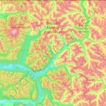
Name: Stephen Mather Wilderness topographic map, elevation, terrain.
Average elevation: 1,120 m
Minimum elevation: 30 m
Maximum elevation: 3,268 m
Thank you for supporting this site ❤️
Make a donation
Make a donation
Other topographic maps
Click on a map to view its topography, its elevation and its terrain.
Thank you for supporting this site ❤️
Make a donation
Make a donation
Thank you for supporting this site ❤️
Make a donation
Make a donation
Whitmarsh Junction
United States > Washington > Skagit County > Anacortes > Whitmarsh Junction
Average elevation: 15 m