
Timis topographic map
Interactive map
Click on the map to display elevation.
About this map
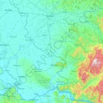
Name: Timis topographic map, elevation, terrain.
Location: Timis, Romania (44.84589 20.41437 45.74035 22.31237)
Average elevation: 188 m
Minimum elevation: 64 m
Maximum elevation: 1,428 m
In the spring of 2007 works on the elevation of the embankments on both banks of the river began, 11.5 kilometers (7.1 mi) on the right bank and 13.2 kilometers (8.2 mi) on the left. The embankments will be 30–70 cm (12–28 in) higher than they are now and being higher than 8.5 m (28 ft) should prevent any future floodings.
Other topographic maps
Click on a map to view its topography, its elevation and its terrain.
Poiana Brașov
Poiana Brașov, Brasov, Zona Metropolitană Brașov, Brașov, 500001, Romania
Average elevation: 1,047 m
Târgu Mureș
Romania > Mureș > Târgu Mureș
Târgu Mureș, Targu Mures Metropolitan Area, Mureș, 540049, Romania
Average elevation: 383 m