
Thank you for supporting this site ❤️
Make a donation
Make a donation
Washington County topographic map
Click on the map to display elevation.
Thank you for supporting this site ❤️
Make a donation
Make a donation
About this map
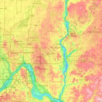
Name: Washington County topographic map, elevation, terrain.
Location: Washington County, Minnesota, United States (44.73774 -93.02205 45.29692 -92.73965)
Average elevation: 284 m
Minimum elevation: 204 m
Maximum elevation: 379 m
Thank you for supporting this site ❤️
Make a donation
Make a donation
Other topographic maps
Click on a map to view its topography, its elevation and its terrain.
Thank you for supporting this site ❤️
Make a donation
Make a donation
Thank you for supporting this site ❤️
Make a donation
Make a donation
Forest Lake
United States > Minnesota > Washington County > Forest Lake > Forest Lake
Average elevation: 277 m
Roseport
United States > Minnesota > Dakota County > Inver Grove Heights > Roseport
Average elevation: 272 m
Thank you for supporting this site ❤️
Make a donation
Make a donation
Thank you for supporting this site ❤️
Make a donation
Make a donation