
Thank you for supporting this site ❤️
Make a donation
Make a donation
Leawood topographic map
Click on the map to display elevation.
Thank you for supporting this site ❤️
Make a donation
Make a donation
About this map
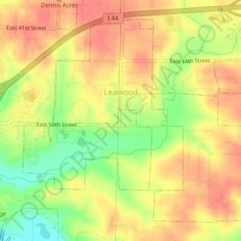
Name: Leawood topographic map, elevation, terrain.
Location: Leawood, Newton County, Missouri, United States (37.02238 -94.51062 37.04516 -94.47900)
Average elevation: 308 m
Minimum elevation: 271 m
Maximum elevation: 330 m
Thank you for supporting this site ❤️
Make a donation
Make a donation
Other topographic maps
Click on a map to view its topography, its elevation and its terrain.
Shoal Creek
United States > Missouri > Newton County > Joplin > Cliff Village
Average elevation: 295 m
Thank you for supporting this site ❤️
Make a donation
Make a donation