
Make a donation
County Wicklow topographic map
Click on the map to display elevation.
Make a donation
County Wicklow
The county experiences a narrow annual temperature range. Typical daytime highs range from 17–22 °C (63–72 °F) throughout the county in July and August, with overnight lows in the 11–14 °C (52–57 °F) range, although temperatures in the mountains can be 5–10 °C (41–50 °F) lower. Mean January temperatures range from 7 °C (45 °F) on the coast to 0 °C (32 °F) at high elevations. Precipitation is fairly evenly distributed throughout the year, although the wettest months (October and November) receive roughly twice as much rain as the driest months (February, March and April). The driest area of Wicklow is the northeast corner of the county, which is protected from the prevailing south-westerly winds by the Wicklow Mountains and receives around 750 mm (30 in) of rainfall per year. The coastal region of County Dublin immediately to the north is the driest location in all of Ireland as a result of the rain shadow created by the mountains.
Make a donation
About this map
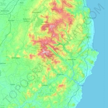
Name: County Wicklow topographic map, elevation, terrain.
Location: County Wicklow, Leinster, Ireland (52.68198 -6.79229 53.23431 -5.99758)
Average elevation: 166 m
Minimum elevation: 0 m
Maximum elevation: 927 m
Make a donation
Other topographic maps
Click on a map to view its topography, its elevation and its terrain.
Mangerton
Mangerton Mountain's height and topographic prominence, qualifies it to meet the British Isles Marilyn classification, as well as the Arderin, Simm and Hewitt classifications. Mangerton Mountain ranks as the 10th-highest mountain in Ireland on the MountainViews Online Database, 100 Highest Irish Mountains,…
Average elevation: 657 m
Make a donation
Blanchardstown
Blanchardstown was a predominantly rural area, with a small village, in western County Dublin, alongside the neighbouring district of Castleknock. Both areas shared a common history until well into the 19th century, when their development diverged. In A Topographical Dictionary of Ireland, published in 1837,…
Average elevation: 61 m
Make a donation
Make a donation
Blue Lake
Ireland > County Limerick > The Municipal District of Adare — Rathkeale > Stonehall
Average elevation: 33 m
Make a donation
Make a donation
Swords
Ireland > County Dublin > Swords
At the northern end of the street stands Swords Castle, 200m northeast of the ecclesiastical site, which was built in the early 13th century. A short distance north of the castle is the elevation known as Spittal Hill, where a hospital once stood.
Average elevation: 28 m
Make a donation
Castleknock
As the word Castle did not come into use in Ireland until Norman times we know that Castleknock is a name of comparatively recent origin. Documents from the 12th and 13th centuries refer to the place as Castrum Cnoc, simply Cnoc and also Chastel-cnoc or Castel-Cnoc.[8] So it seems that the name Castleknock is…
Average elevation: 55 m
Gooseberry Hill
Ireland > County Limerick > The Municipal District of Cappamore — Kilmallock
Average elevation: 217 m
Make a donation