
Thank you for supporting this site ❤️
Make a donation
Make a donation
Menlo topographic map
Click on the map to display elevation.
Thank you for supporting this site ❤️
Make a donation
Make a donation
About this map
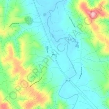
Name: Menlo topographic map, elevation, terrain.
Location: Menlo, Pacific County, Washington, United States (46.60149 -123.66710 46.64149 -123.62710)
Average elevation: 61 m
Minimum elevation: 6 m
Maximum elevation: 195 m
Thank you for supporting this site ❤️
Make a donation
Make a donation
Other topographic maps
Click on a map to view its topography, its elevation and its terrain.