
Thank you for supporting this site ❤️
Make a donation
Make a donation
South Bend topographic map
Click on the map to display elevation.
Thank you for supporting this site ❤️
Make a donation
Make a donation
About this map
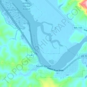
Name: South Bend topographic map, elevation, terrain.
Location: South Bend, Pacific County, Washington, United States (46.65885 -123.82762 46.68934 -123.76746)
Average elevation: 23 m
Minimum elevation: -6 m
Maximum elevation: 317 m
Thank you for supporting this site ❤️
Make a donation
Make a donation
Other topographic maps
Click on a map to view its topography, its elevation and its terrain.