
Make a donation
Taconic Shores topographic map
Click on the map to display elevation.
Make a donation
About this map
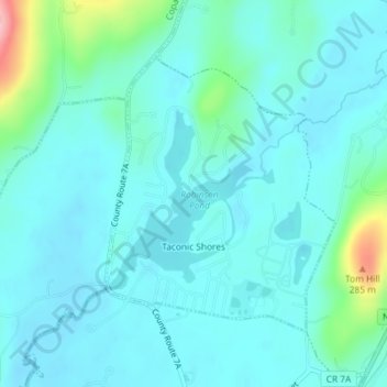
Name: Taconic Shores topographic map, elevation, terrain.
Average elevation: 180 m
Minimum elevation: 156 m
Maximum elevation: 307 m
Make a donation
Other topographic maps
Click on a map to view its topography, its elevation and its terrain.
Make a donation
Make a donation
Make a donation
Make a donation
Make a donation
Make a donation
Upper Hollowville
United States > New York > Columbia County > Town of Claverack
Average elevation: 190 m
Make a donation
Make a donation
Make a donation
North Hillsdale
United States > New York > Columbia County > Town of Hillsdale
Average elevation: 308 m
Valatie Colony
United States > New York > Columbia County > Town of Kinderhook
Average elevation: 94 m
Make a donation
Linlithgo Mills
United States > New York > Columbia County > Town of Livingston
Average elevation: 76 m
Lebanon Springs
United States > New York > Columbia County > Town of New Lebanon
Average elevation: 314 m
Make a donation
New Lebanon Center
United States > New York > Columbia County > Town of New Lebanon
Average elevation: 284 m
West Lebanon
United States > New York > Columbia County > Town of New Lebanon
Average elevation: 243 m
Make a donation
East Taghkanic
United States > New York > Columbia County > Town of Taghkanic
Average elevation: 200 m
Make a donation
West Taghkanic
United States > New York > Columbia County > Town of Taghkanic
Average elevation: 147 m
Stuyvesant Falls
United States > New York > Columbia County > Town of Stuyvesant
Average elevation: 58 m
Make a donation
Make a donation