
Thank you for supporting this site ❤️
Make a donation
Make a donation
West Copake topographic map
Click on the map to display elevation.
Thank you for supporting this site ❤️
Make a donation
Make a donation
About this map
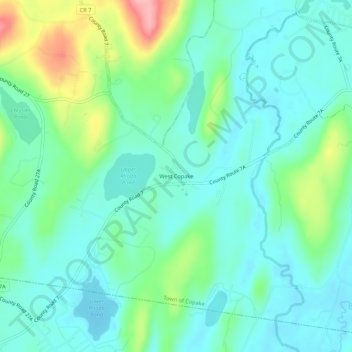
Name: West Copake topographic map, elevation, terrain.
Average elevation: 181 m
Minimum elevation: 150 m
Maximum elevation: 272 m
Thank you for supporting this site ❤️
Make a donation
Make a donation
Other topographic maps
Click on a map to view its topography, its elevation and its terrain.
Nutten Hook State Tidal Wetland
United States > New York > Columbia County > Town of Stuyvesant
Average elevation: 32 m
Thank you for supporting this site ❤️
Make a donation
Make a donation
Olana State Historic Site
United States > New York > Columbia County > Greendale
Average elevation: 52 m
Copake Lake
United States > New York > Columbia County > Town of Copake > Copake Lake
Average elevation: 235 m
Thank you for supporting this site ❤️
Make a donation
Make a donation
Thank you for supporting this site ❤️
Make a donation
Make a donation
Thank you for supporting this site ❤️
Make a donation
Make a donation
Thank you for supporting this site ❤️
Make a donation
Make a donation
Thank you for supporting this site ❤️
Make a donation
Make a donation