
Make a donation
Devils Elbow topographic map
Click on the map to display elevation.
Make a donation
About this map
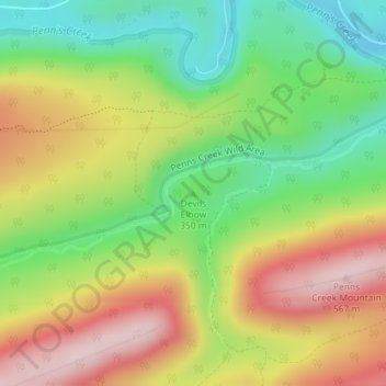
Name: Devils Elbow topographic map, elevation, terrain.
Average elevation: 387 m
Minimum elevation: 235 m
Maximum elevation: 564 m
Make a donation
Other topographic maps
Click on a map to view its topography, its elevation and its terrain.
Make a donation
Make a donation
Mill Run
United States > Pennsylvania > Blair County > Altoona > Allegheny Furnace
Average elevation: 349 m
Make a donation
Make a donation
Make a donation
Make a donation
Make a donation
Martin's Creek
United States > Pennsylvania > Northampton County > Lower Mount Bethel Township > Martins Creek
Average elevation: 152 m
Make a donation
Sullivan County
Elevation ranges from 2593 ft at North Mountain in Davidson Township to 779 ft on Loyalsock Creek at the Lycoming County line. The county is served by Pennsylvania Route 42, Pennsylvania Route 87, Pennsylvania Route 154, Pennsylvania Route 487, and U.S. Route 220. The major rivers in the county are Loyalsock…
Average elevation: 491 m
Make a donation
Bob Case Park
United States > Pennsylvania > Montgomery County > Upper Merion Township > King of Prussia > Sweet Briar
Average elevation: 45 m
Make a donation
Chester
United States > Pennsylvania > Delaware County > Chester
Being at a low elevation between Philadelphia and Wilmington, Chester experiences a humid subtropical climate (Cfa.) The hardiness zone is 7b. Archived 2014-02-09 at the Wayback Machine
Average elevation: 10 m
Make a donation
King of Prussia
United States > Pennsylvania > Montgomery County > King of Prussia
Average elevation: 59 m
Make a donation
South Strabane Township
United States > Pennsylvania > Washington County > South Strabane Township
Average elevation: 358 m
Willow Grove
United States > Pennsylvania > Montgomery County > Upper Moreland Township > Willow Grove
Average elevation: 88 m
Make a donation
Tamaqua
United States > Pennsylvania > Schuylkill County
Tamaqua's average elevation is 870 feet (270 m) above sea level, but elevations can reach up to 1,000 feet (300 m) above sea level.
Average elevation: 352 m
Brackenridge
United States > Pennsylvania > Allegheny County
Brackenridge is located at 40°36′30″N 79°44′32″W / 40.60833°N 79.74222°W / 40.60833; -79.74222. The borough's average elevation is 827 feet (252 m) above sea level.
Average elevation: 266 m
Make a donation
Make a donation