
Make a donation
Yavneel topographic map
Click on the map to display elevation.
Make a donation
About this map
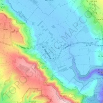
Name: Yavneel topographic map, elevation, terrain.
Location: Yavneel, Kinneret Subdistrict, North District, Israel (32.67476 35.47616 32.74553 35.54692)
Average elevation: 69 m
Minimum elevation: -175 m
Maximum elevation: 363 m
Make a donation
Other topographic maps
Click on a map to view its topography, its elevation and its terrain.
Tiberias
Tiberias is located on the shore of the Sea of Galilee and the western slopes of the Jordan Rift Valley overlooking the lake, in the elevation range of −200 to 200 metres (−660–660 feet). Tiberias has a climate that borders a Hot-summer Mediterranean climate (koppen Csa) and a Hot Semi-arid climate…
Average elevation: -78 m
Make a donation
Make a donation
2236 Mt. Hermon
Israel > North District > Golan Regional Council
Mount Hermon (Arabic: جبل الشيخ or جبل حرمون / ALA-LC: Jabal al-Shaykh ('Mountain of the Sheikh') or Jabal Haramun; Hebrew: הַר חֶרְמוֹן, Har Ḥermōn) is a mountain cluster constituting the southern end of the Anti-Lebanon mountain range. Its summit straddles the border between…
Average elevation: 2,016 m
Make a donation