
Make a donation
Tiberias topographic map
Click on the map to display elevation.
Make a donation
Tiberias
Tiberias is located on the shore of the Sea of Galilee and the western slopes of the Jordan Rift Valley overlooking the lake, in the elevation range of −200 to 200 metres (−660–660 feet). Tiberias has a climate that borders a Hot-summer Mediterranean climate (koppen Csa) and a Hot Semi-arid climate (koppen BSh), with an annual precipitation of about 400 mm (15.75 in). Summers in Tiberias average a maximum temperature of 36 °C (97 °F) and a minimum temperature of 21 °C (70 °F) in July and August. The winters are mild, with temperatures ranging from 8 to 18 °C (46–64 °F). Extremes have ranged from 0 °C (32 °F) to 46 °C (115 °F).
Make a donation
About this map
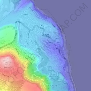
Name: Tiberias topographic map, elevation, terrain.
Location: Tiberias, Kinneret Subdistrict, North District, Israel (32.77400 35.49869 32.80449 35.54449)
Average elevation: -78 m
Minimum elevation: -218 m
Maximum elevation: 249 m
Make a donation
Other topographic maps
Click on a map to view its topography, its elevation and its terrain.
Sea of Galilee
The Sea of Galilee (Hebrew: יָם כִּנֶּרֶת, Judeo-Aramaic: יַמּא דטבריא, גִּנֵּיסַר, Arabic: بحيرة طبريا), also called Lake Tiberias, Genezareth Lake or Kinneret, is a freshwater lake in Israel. It is the lowest freshwater lake on Earth and the second-lowest lake in…
Average elevation: -67 m
Golan Heights
The plateau that Israel controls is part of a larger area of volcanic basalt fields stretching north and east that were created in the series of volcanic eruptions that began recently in geological terms, almost 4 million years ago. The rock forming the mountainous area in the northern Golan Heights,…
Average elevation: 524 m
Make a donation
Kiryat Shmona
Kiryat Shmona is located in the Finger of the Galilee next to Hula Valley, about 5 kilometres (3 miles) south and 2 km (1 mile) east of the Israel–Lebanon border. Its elevation is about 150 metres (492 feet) above sea level.
Average elevation: 237 m
2236 Mt. Hermon
Israel > North District > Golan Regional Council
Mount Hermon (Arabic: جبل الشيخ or جبل حرمون / ALA-LC: Jabal al-Shaykh ('Mountain of the Sheikh') or Jabal Haramun; Hebrew: הַר חֶרְמוֹן, Har Ḥermōn) is a mountain cluster constituting the southern end of the Anti-Lebanon mountain range. Its summit straddles the border between…
Average elevation: 2,016 m
Make a donation
Make a donation