
Golan Heights topographic map
Click on the map to display elevation.
Golan Heights
The plateau that Israel controls is part of a larger area of volcanic basalt fields stretching north and east that were created in the series of volcanic eruptions that began recently in geological terms, almost 4 million years ago. The rock forming the mountainous area in the northern Golan Heights, descending from Mount Hermon, differs geologically from the volcanic rocks of the plateau and has a different physiography. The mountains are characterised by lighter-colored, Jurassic-age limestone of sedimentary origin. Locally, the limestone is broken by faults and solution channels to form a karst-like topography in which springs are common.
About this map
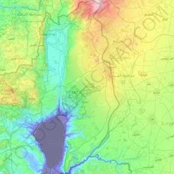
Name: Golan Heights topographic map, elevation, terrain.
Location: Golan Heights, North District, Israel (32.68213 35.61332 33.33563 35.89502)
Average elevation: 524 m
Minimum elevation: -222 m
Maximum elevation: 2,351 m
Other topographic maps
Click on a map to view its topography, its elevation and its terrain.
Tiberias
Tiberias is located on the shore of the Sea of Galilee and the western slopes of the Jordan Rift Valley overlooking the lake, in the elevation range of −200 to 200 metres (−660–660 feet). Tiberias has a climate that borders a Hot-summer Mediterranean climate (koppen Csa) and a Hot Semi-arid climate…
Average elevation: -78 m
2236 Mt. Hermon
Israel > North District > Golan Regional Council
Mount Hermon (Arabic: جبل الشيخ or جبل حرمون / ALA-LC: Jabal al-Shaykh ('Mountain of the Sheikh') or Jabal Haramun; Hebrew: הַר חֶרְמוֹן, Har Ḥermōn) is a mountain cluster constituting the southern end of the Anti-Lebanon mountain range. Its summit straddles the border between…
Average elevation: 2,016 m