
Thank you for supporting this site ❤️
Make a donation
Make a donation
Newtonia topographic map
Click on the map to display elevation.
Thank you for supporting this site ❤️
Make a donation
Make a donation
About this map
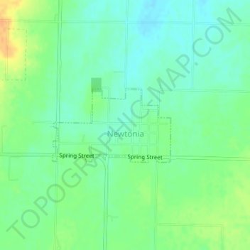
Name: Newtonia topographic map, elevation, terrain.
Location: Newtonia, Newton County, Missouri, United States (36.87596 -94.19244 36.88396 -94.17648)
Average elevation: 370 m
Minimum elevation: 358 m
Maximum elevation: 390 m
Thank you for supporting this site ❤️
Make a donation
Make a donation
Other topographic maps
Click on a map to view its topography, its elevation and its terrain.
Shoal Creek
United States > Missouri > Newton County > Joplin > Cliff Village
Average elevation: 295 m
Thank you for supporting this site ❤️
Make a donation
Make a donation