
Make a donation
Howland topographic map
Click on the map to display elevation.
Make a donation
About this map
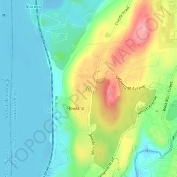
Name: Howland topographic map, elevation, terrain.
Average elevation: 37 m
Minimum elevation: -14 m
Maximum elevation: 107 m
Make a donation
Other topographic maps
Click on a map to view its topography, its elevation and its terrain.
Shenandoah
United States > New York > Dutchess County > Town of East Fishkill
Average elevation: 153 m
Annandale-on-Hudson
United States > New York > Dutchess County > Town of Red Hook
Average elevation: 43 m
Make a donation
Rhinecliff
United States > New York > Dutchess County > Town of Rhinebeck
The hamlet is demarcated by large agricultural and wooded area to the north, east, and south, and bounded by the Hudson River on the west. Steep topography, formed by contorted slate ridges and valleys, define the site-specific and seemingly random orientation of the small, frame nineteenth-century houses and…
Average elevation: 19 m
Timothy Heights
United States > New York > Dutchess County > Town of Pleasant Valley
Average elevation: 87 m
Make a donation
Make a donation
Make a donation
Pecksville
United States > New York > Dutchess County > Town of East Fishkill
Average elevation: 274 m
Make a donation
Stormville
United States > New York > Dutchess County > Town of East Fishkill
Average elevation: 112 m
Make a donation
Make a donation
Netherwood
United States > New York > Dutchess County > Town of Pleasant Valley
Average elevation: 110 m
Make a donation
Make a donation
Make a donation
Make a donation
Make a donation
Salt Point
United States > New York > Dutchess County > Town of Pleasant Valley
Average elevation: 97 m