
Thank you for supporting this site ❤️
Make a donation
Make a donation
Wolf Run topographic map
Click on the map to display elevation.
Thank you for supporting this site ❤️
Make a donation
Make a donation
About this map
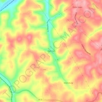
Name: Wolf Run topographic map, elevation, terrain.
Location: Wolf Run, Jefferson County, Ohio, 43970, United States (40.44729 -80.90925 40.48729 -80.86925)
Average elevation: 359 m
Minimum elevation: 274 m
Maximum elevation: 410 m
Thank you for supporting this site ❤️
Make a donation
Make a donation
Other topographic maps
Click on a map to view its topography, its elevation and its terrain.