
Make a donation
Abruzzo topographic map
Click on the map to display elevation.
Make a donation
Abruzzo
In Abruzzo there are two climatic zones. The coastal strip and sub-Apennine hills have a climate markedly different from that of the mountainous interior. Coastal areas have a Mediterranean climate with hot dry summers and mild winters. Inland hilly areas have a sublittoral climate with temperatures decreasing progressively with increasing altitude. Precipitation is also strongly affected by the presence of the Apennines mountain range. Rainfall is abundant on slopes oriented to the west, and lower in east and east-facing slopes. The Adriatic coast is shielded from rainfall by the barrier effect created by the Apennines. The minimum annual rainfall is found in some inland valleys, sheltered by mountain ranges, such as Peligna or Tirino (Ofena, Capestrano), where as little as 500 millimetres (19.7 inches) were recorded. Rainfall along the coast almost always never falls below 600 millimetres (23.6 inches). Pescara has relatively less rainfall (about 700 millimetres (27.6 inches)) than Chieti (about 1,000 millimetres (39.4 inches)). The highest rainfall occurs in upland areas on the border with Lazio; they are especially vulnerable to Atlantic disturbances. Around 1,500 to 2,000 millimetres (59 to 79 inches) of precipitation is typical.
Make a donation
About this map
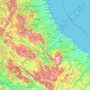
Name: Abruzzo topographic map, elevation, terrain.
Location: Abruzzo, Italy (41.68204 13.01897 42.89508 14.78389)
Average elevation: 658 m
Minimum elevation: -1 m
Maximum elevation: 2,775 m
Make a donation
Other topographic maps
Click on a map to view its topography, its elevation and its terrain.
Make a donation
Make a donation
Mount Vesuvius
Italy > Campania > Naples > Trecase
The volcano's slopes are scarred by lava flows, while the rest are heavily vegetated, with scrub and forests at higher altitudes and vineyards lower down.
Average elevation: 862 m
Make a donation
Make a donation
Make a donation
Vetzan - Vezzano
Italy > Trentino-Alto Adige/Südtirol > South Tyrol > Schlanders - Silandro
Average elevation: 978 m
Make a donation
Laimburg - Castel Varco
Italy > Trentino-Alto Adige/Südtirol > South Tyrol > Vadena - Pfatten
Average elevation: 321 m
Muls
Italy > Trentino-Alto Adige/Südtirol > South Tyrol > Sarntal - Sarentino
Average elevation: 1,678 m
Make a donation
Rolle Pass
Italy > Trentino – Alto Adige/Südtirol > Provincia di Trento > San Martino di Castrozza
Due to altitude, the climate is subarctic (Köppen: Dfc), similar to other high mountains in the Alps. The annual average temperature is 3.2 °C (37.8 °F), the hottest month in July is 11.8 °C (53.2 °F), and the coldest month is −4.4 °C (24.1 °F) in February. The annual precipitation is 1,004.11…
Average elevation: 1,996 m
Make a donation
Make a donation
Make a donation
San Rocco Castagnaretta
Italy > Piedmont > Cuneo > Cuneo > San Rocco Castagnaretta
Average elevation: 569 m
Urban
Italy > Trentino-Alto Adige/Südtirol > Unsere Liebe Frau im Walde-St. Felix - Senale-San Felice > Unsere Liebe Frau im Walde - Senale > Urban
Average elevation: 1,530 m
Make a donation
Baldal
Italy > Trentino-Alto Adige/Südtirol > Provincia di Trento > Palù del Fersina - Palai en Bersntol > Palai en Bersntol - Palù del Fersina
Average elevation: 1,758 m
Make a donation
Palette
Italy > Trentino-Alto Adige/Südtirol > Provincia di Trento > Spiazzo
Average elevation: 1,714 m
Make a donation