
Make a donation
Cornelius topographic map
Click on the map to display elevation.
Make a donation
Cornelius
Cornelius is located along Lake Norman in northern Mecklenburg County. The town lies approximately 20 miles (30 km) north of Charlotte, at an elevation of 742 feet (226 m). It is bordered to the north and east by the town of Davidson and to the south by the town of Huntersville.
Make a donation
About this map
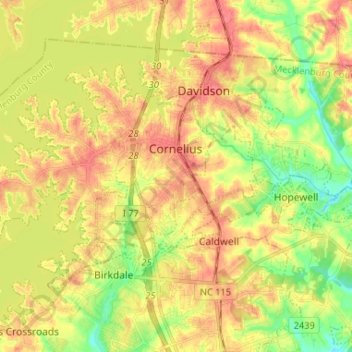
Name: Cornelius topographic map, elevation, terrain.
Location: Cornelius, Mecklenburg County, North Carolina, United States (35.43927 -80.94650 35.50733 -80.81611)
Average elevation: 232 m
Minimum elevation: 199 m
Maximum elevation: 260 m
Make a donation
Other topographic maps
Click on a map to view its topography, its elevation and its terrain.
Spring Valley
United States > North Carolina > Mecklenburg County > Charlotte
Average elevation: 201 m
Make a donation
Griffith Lakes
United States > North Carolina > Mecklenburg County > Charlotte
Average elevation: 244 m
Make a donation
Ballantyne's Backyard
United States > North Carolina > Mecklenburg County > Charlotte
Average elevation: 183 m
Carolina Harbor
United States > North Carolina > Mecklenburg County > Charlotte
Average elevation: 187 m
Make a donation
Tuckaseegee Park
United States > North Carolina > Mecklenburg County > Charlotte
Average elevation: 233 m
Providence Plantation
United States > North Carolina > Mecklenburg County > Charlotte
Average elevation: 205 m
Make a donation
Reedy Creek Regional Park
United States > North Carolina > Mecklenburg County > Charlotte
Average elevation: 229 m
Old Providence
United States > North Carolina > Mecklenburg County > Charlotte
Average elevation: 192 m
Sharon Colony
United States > North Carolina > Mecklenburg County > Charlotte
Average elevation: 201 m
Make a donation
Providence Plantation
United States > North Carolina > Mecklenburg County > Charlotte
Average elevation: 205 m
Make a donation
Park on Wilgrove
United States > North Carolina > Mecklenburg County > Charlotte > Lakeland Hills
Average elevation: 232 m
Make a donation
Providence Plantation
United States > North Carolina > Mecklenburg County > Charlotte
Average elevation: 205 m
Montclaire South
United States > North Carolina > Mecklenburg County > Charlotte
Average elevation: 202 m
Make a donation
Providence Plantation
United States > North Carolina > Mecklenburg County > Charlotte > Providence Plantation
Average elevation: 200 m
Coulwood Hills
United States > North Carolina > Mecklenburg County > Charlotte > Coulwood Hills
Average elevation: 213 m
Make a donation