
Make a donation
Dixie topographic map
Click on the map to display elevation.
Make a donation
About this map
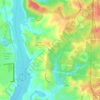
Name: Dixie topographic map, elevation, terrain.
Average elevation: 198 m
Minimum elevation: 173 m
Maximum elevation: 232 m
Make a donation
Other topographic maps
Click on a map to view its topography, its elevation and its terrain.
Charlotte
United States > North Carolina > Mecklenburg County
Charlotte, located in the Piedmont region of North Carolina, features a gently rolling terrain characterized by elevations ranging from approximately 650 to 700 feet (198 to 213 meters). The city is bordered to the west by the Catawba River, which contributes to the area's mild climate and lush vegetation.…
Average elevation: 207 m
Charlotte
United States > North Carolina > Mecklenburg County
According to the United States Census Bureau, the city has a total area of 308.6 square miles (799 km2), of which 306.6 square miles (794 km2) is land and 2.0 square miles (5.2 km2) is water. Charlotte is the twenty-sixth-most expansive city in the United States and lies at an elevation of 751 feet (229 m).…
Average elevation: 207 m
Cornelius
United States > North Carolina > Mecklenburg County
Cornelius is located along Lake Norman in northern Mecklenburg County. The town lies approximately 20 miles (30 km) north of Charlotte, at an elevation of 742 feet (226 m). It is bordered to the north and east by the town of Davidson and to the south by the town of Huntersville.
Average elevation: 232 m
Make a donation
Griffith Lakes
United States > North Carolina > Mecklenburg County > Charlotte
Average elevation: 244 m
Ballantyne's Backyard
United States > North Carolina > Mecklenburg County > Charlotte
Average elevation: 183 m
Carolina Harbor
United States > North Carolina > Mecklenburg County > Charlotte
Average elevation: 187 m
Make a donation
Tuckaseegee Park
United States > North Carolina > Mecklenburg County > Charlotte
Average elevation: 233 m
Charlotte
United States > North Carolina > Mecklenburg County
According to the United States Census Bureau, the city has a total area of 312.00 square miles (808.1 km2), of which 310.02 square miles (802.9 km2) is land and 1.98 square miles (5.1 km2) (0.63%) is water. Charlotte is the twenty-sixth-most expansive city in the United States and lies at an elevation of 751…
Average elevation: 207 m
Make a donation
Providence Plantation
United States > North Carolina > Mecklenburg County > Charlotte
Average elevation: 205 m
Reedy Creek Regional Park
United States > North Carolina > Mecklenburg County > Charlotte
Average elevation: 229 m
Providence Plantation
United States > North Carolina > Mecklenburg County > Charlotte
Average elevation: 205 m
Make a donation
Charlotte
United States > North Carolina > Mecklenburg County
According to the United States Census Bureau, the city has a total area of 312.00 square miles (808.1 km2), of which 310.02 square miles (802.9 km2) is land and 1.98 square miles (5.1 km2) (0.63%) is water. Charlotte is the twenty-sixth-most expansive city in the United States and lies at an elevation of 751…
Average elevation: 207 m
Make a donation
Charlotte
United States > North Carolina > Mecklenburg County
According to the United States Census Bureau, the city has a total area of 312.00 square miles (808.1 km2), of which 310.02 square miles (802.9 km2) is land and 1.98 square miles (5.1 km2) (0.63%) is water. Charlotte is the twenty-sixth-most expansive city in the United States and lies at an elevation of 751…
Average elevation: 207 m
Park on Wilgrove
United States > North Carolina > Mecklenburg County > Charlotte > Lakeland Hills
Average elevation: 232 m
Abersham Regional Park
United States > North Carolina > Mecklenburg County > Davidson
Average elevation: 226 m
Charlotte
United States > North Carolina > Mecklenburg County
According to the United States Census Bureau, the city has a total area of 312.00 square miles (808.1 km2), of which 310.02 square miles (802.9 km2) is land and 1.98 square miles (5.1 km2) (0.63%) is water. Charlotte is the twenty-sixth-most expansive city in the United States and lies at an elevation of 751…
Average elevation: 207 m
Make a donation
Charlotte
United States > North Carolina > Mecklenburg County
According to the United States Census Bureau, the city has a total area of 312.00 square miles (808.1 km2), of which 310.02 square miles (802.9 km2) is land and 1.98 square miles (5.1 km2) (0.63%) is water. Charlotte is the twenty-sixth-most expansive city in the United States and lies at an elevation of 751…
Average elevation: 207 m
Make a donation
Providence Plantation
United States > North Carolina > Mecklenburg County > Charlotte
Average elevation: 205 m
Make a donation