
Thank you for supporting this site ❤️
Make a donation
Make a donation
Kapuskasing topographic map
Click on the map to display elevation.
Thank you for supporting this site ❤️
Make a donation
Make a donation
Kapuskasing
Kapuskasing lies in the heart of the Great Clay Belt. The topography of the region is very flat, dotted with numerous small lakes and muskeg bogs. Also in the heart of Canada's boreal forest, the region is drained by rivers running north to James Bay. The district is heavily forested, mostly by thick stands of black spruce that have commercial value as pulpwood.
Thank you for supporting this site ❤️
Make a donation
Make a donation
About this map
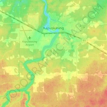
Name: Kapuskasing topographic map, elevation, terrain.
Average elevation: 227 m
Minimum elevation: 202 m
Maximum elevation: 249 m
Thank you for supporting this site ❤️
Make a donation
Make a donation
Other topographic maps
Click on a map to view its topography, its elevation and its terrain.
Albany Island
Canada > Ontario > Cochrane District > Unorganized North Cochrane
Average elevation: 12 m
Thank you for supporting this site ❤️
Make a donation
Make a donation