
Thank you for supporting this site ❤️
Make a donation
Make a donation
Pearl Point topographic map
Click on the map to display elevation.
Thank you for supporting this site ❤️
Make a donation
Make a donation
About this map
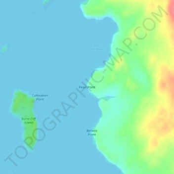
Name: Pearl Point topographic map, elevation, terrain.
Average elevation: 13 m
Minimum elevation: -2 m
Maximum elevation: 64 m
Thank you for supporting this site ❤️
Make a donation
Make a donation
Other topographic maps
Click on a map to view its topography, its elevation and its terrain.
Ducie Island
Canada > British Columbia > North Coast Regional District > Area A (North Skeena)
Average elevation: 1 m
Zayas Island
Canada > British Columbia > North Coast Regional District > Area A (North Skeena)
Average elevation: 7 m