
Make a donation
Harpeth River topographic map
Click on the map to display elevation.
Make a donation
About this map
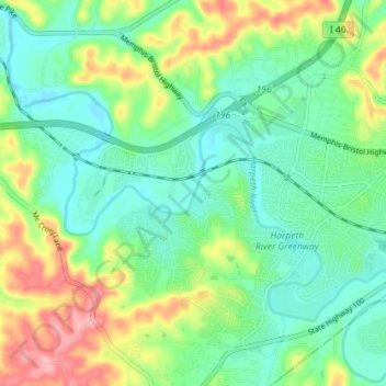
Name: Harpeth River topographic map, elevation, terrain.
Average elevation: 197 m
Minimum elevation: 155 m
Maximum elevation: 284 m
Make a donation
Other topographic maps
Click on a map to view its topography, its elevation and its terrain.
Radnor Lake State Natural Area
United States > Tennessee > Davidson County > Nashville-Davidson
Average elevation: 265 m
Make a donation
Make a donation
Little Creek
United States > Tennessee > Davidson County > Nashville-Davidson
Average elevation: 194 m
Make a donation
Town Park Estates
United States > Tennessee > Davidson County > Nashville-Davidson
Average elevation: 174 m
Cherry Hills
United States > Tennessee > Davidson County > Nashville-Davidson
Average elevation: 166 m
Make a donation
Colewood Acres
United States > Tennessee > Davidson County > Nashville-Davidson
Average elevation: 184 m
Whites Creek
United States > Tennessee > Davidson County > Nashville-Davidson
Average elevation: 180 m
Edge-O-Lake Estates
United States > Tennessee > Davidson County > Nashville-Davidson
Average elevation: 175 m
Make a donation
Myrtlewood Estates
United States > Tennessee > Davidson County > Nashville-Davidson
Average elevation: 206 m
Make a donation
Lake Wautaga
United States > Tennessee > Davidson County > Nashville-Davidson
Average elevation: 168 m