
Make a donation
Bakers topographic map
Click on the map to display elevation.
Make a donation
About this map
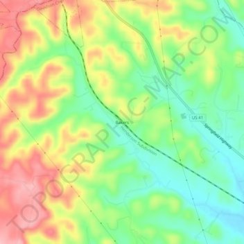
Name: Bakers topographic map, elevation, terrain.
Average elevation: 212 m
Minimum elevation: 149 m
Maximum elevation: 288 m
Make a donation
Other topographic maps
Click on a map to view its topography, its elevation and its terrain.
Radnor Lake State Natural Area
United States > Tennessee > Davidson County > Nashville-Davidson
Average elevation: 265 m
Lockeland Springs Park
United States > Tennessee > Davidson County > Nashville-Davidson
Average elevation: 149 m
Whites Creek
United States > Tennessee > Davidson County > Nashville-Davidson
Average elevation: 143 m
Make a donation
Antioch Park
United States > Tennessee > Davidson County > Nashville-Davidson > Antioch
Average elevation: 173 m
Hermitage Island
United States > Tennessee > Davidson County > Nashville-Davidson
Average elevation: 157 m
Harpeth River
United States > Tennessee > Davidson County > Nashville-Davidson
Average elevation: 197 m
Make a donation
Lake Wautaga
United States > Tennessee > Davidson County > Nashville-Davidson
Average elevation: 168 m