
Wasaga Beach Provincial Park topographic map
Interactive map
Click on the map to display elevation.
About this map
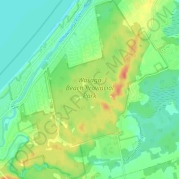
Name: Wasaga Beach Provincial Park topographic map, elevation, terrain.
Average elevation: 188 m
Minimum elevation: 172 m
Maximum elevation: 214 m
The Town of Wasaga Beach covers an area of 61.13 square kilometres (23.60 sq mi) comprised predominantly of sand and loamy sand that exhibit excessive to good drainage and irregular to moderately sloping topography. The poor soil quality makes it difficult to sustain lush lawns in the town. The Canada Land Inventory for Agriculture rates the lands as predominately Class Six and Seven with primary restrictions of adverse topography, erosion damage and low natural fertility.
Other topographic maps
Click on a map to view its topography, its elevation and its terrain.
Wasaga Beach Provincial Park
Canada > Ontario > Simcoe County > Wasaga Beach
Wasaga Beach Provincial Park, 11, Wasaga Beach, Simcoe County, Central Ontario, Ontario, L9Z 2V9, Canada
Average elevation: 185 m
Springhurst Beach
Canada > Ontario > Simcoe County > Wasaga Beach > Springhurst Beach
Springhurst Beach, Wasaga Beach, Simcoe County, Central Ontario, Ontario, L0L 2P0, Canada
Average elevation: 184 m